Name
EnisalaCurrent Name
EnisalaAncient Name
Vicus NovusMedieval Name
Yeni-Sale, Enisala, Enişala, Heraclee or HeracliaHistory of the name
The history of the city and the nearby settlement is illustrated also by the names which it had in the past: from Vicus Novus (translated New Village) to Novoe Selo, a name taken over by the Turks in their language resulting Yeni-Sale and subsequently derived the current name of the village Enisala.
Place :
Country
RomaniaGeopolitical Unit
South East EuropeAdministrative subdivision
Sarichioi, Constanta CountyLocation
The ruins of the medieval city Yeni-Sale (Enisala, Enişala, Heraclee or Heraclia) are located 2 km from Enisala locality on a limestone hill that dominates lakes Razim and Babadag; on the western side there are vertical walls of rock of about 70 m height (the fortification is 116 meters above the sea level); 44° 53' N and 28° 40' E.Foudation Date
late 13th – early 14th centuryCurrent condition
archaeological site, situated 2 km away from the actual Enisala villageHistory
After examining the navigation maps from 13th-14th centuries, the locality that appears as Bambola, Pampulo has been identified with the city Enisala. It was first mentioned as Yeni-Sale in the 15th century, in the chronicle of Sükrüllah, when he talks about the cities conquered in Dobrudja by Bayazid Ildîrîm during the campaign of 1388-89. At that time, Babadag Lake was united with Lake Razim and the latter was nothing but a huge golf at the Black Sea. The location of the city Enisala was extremely favorable, situated more or less in the center of Dobrudja and so controlling both land and maritime routs. Between 1397-1418, during the reign of Mircea the Elder, the city was part of the defensive system of Wallachia. After Dobrudja was conquered by the Turks in 1419-1420, an Ottoman garrison was installed here (150-200 soldiers). Mehmed I Celebi defeated the garrison from Enisala in 1416-17 and he will undertake restoration works because, as Sükrüllah says, the cities here “were ruined because of mindless infidels”. Strange is that during excavations we have not found any traces of a siege; this can be explained by the fact that after the last siege, the city has been used for a while before being abandoned; so, it did not have a violent end with traces that could have been preserved. Turkish rule will cover during the entire 15th century and at the end of this century or the beginning of the next it was abandoned (coins dated to the 16th century are missing) due to the loss of strategic importance once the sand cords that will isolate Lake Babadag from Lake Razim were formed. In the 16th century it no longer meets the Ottoman strategic and economic needs. Polish agent Korsac mentions it in 1849 and then Ion Ionescu de la Brad in 1850 as Ienisali.
Description
The site is located in an archaeological complex with numerous vestiges from Paleolithic epoch to the Middle Ages. The archaeological researches started in 1939 and continued with interruptions in the 7th-8th decades of the 20th century. The medieval dwelling has two levels of housing. The first one, which is prior to the building of the fortification, was dated based on the archaeological material from late 13th century – beginning of the 14th century. The second level corresponds to the period when the walls were erected.
Archeological researches undertaken before World War II and then continued in the 70s of the 20th century have reveled very thin archaeological deposits due to the stony soil. There were discovered levels of housing from 13th-14th centuries until the end of the 15th century. There was investigated in the area also a late medieval Christian necropolis. Excavations led to the discovery of numerous adornments and clothing items, Ottoman and European coins.
Numerous pieces discovered as a result of archaeological researches (weapons, tools, pottery, adornments etc.) and especially Byzantine, Genoese, Moldavian, Wallachian or Turkish coins attest the military, political, administrative and economic role of the city over time.
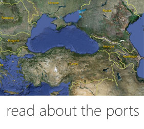
Harbor
Although the archaeological campaigns did not uncover any of the harbor installations of Enisala, at the foot of the hill guarded by the city must have been a port facility. It is proven by the large quantity of imported material discovered at Enisala as well as by its strategic location and especially by the information provided by the medieval navigation maps. Since during the medieval period the nowdays lagoon Razelm Sinoe was not fully silted the access of ships towards Enisala fortress was granted.
Fortification
The city had a military and defensive role but also to monitor roads by sea and by land and was built in late 14th century by an authority aimed at the Danube area. Based on building techniques, archaeological material and historical reality it was suggested that the only ones who were interested in building a city part of the fortification system from Northern Dobrudja, sea-oriented for vessel traffic control, were the Genoese merchants who had large amounts of money earned from trade and who had the monopoly on the Black Sea navigation.
The fortification from Enisala was part of the Genoese colony chain which included the cities at the Danube mouths. The city has an irregular polygonal plan which is in fact adapted to the land – quadrangle with towers at the corners. Normally, a longer curtain wall needed to be protected by more towers. It is noteworthy that three of the towers have a hexagonal shape, a unique case for Dobrudja and as well for Wallachia. We may consider that this shape stands between the rectangular and the circular. This pattern is also found both in East and in West. The precinct walls, city towers and bastions, partially preserved and restored, are mostly maintained at a height of 5-0 m.
The main entrance is on the south, flanked on the east by a hexagonal tower which has shooting windows parallel to the curtain wall; access was from the watch road and the traces of this entrance are still visible. A second gate was on the north, flanked on the west by a square plan tower, also with embrasures; inside we can identify traces of the shooting galleries. This second entrance used to facilitate communication with the alleged port from the above mentioned village. The main entrance is three meters wide and four meters height. There were other two hexagonal towers at the north-east and south-east corners and a square plan tower at the middle of the north sides. The western curtain wall is protected by the steep hill and therefore there are no additional fortifications; there is just a massive, rectangular shaped masonry spur for support.
We may notice, on the inner part of the south-east curtain wall, the foundations of what is assumed to be the residence for the garrison’s Captain; at the basement is a possible prison. The other buildings (most of them were made of wood) were clustered along the walls and therefore remained an open space in the center, free for the weapons market.
In conclusion, the main gate bastion stands apart as a remarkable architectural element of Oriental origin, with double arch commonly found in the Middle Ages and used by Byzantine builders in various buildings in the Balkan Peninsula but also in the Romanian Principalities. Archaeological excavations from 1963-1964 have partially uncovered, at 35-75 m from the opened precinct, the traces of another precinct which was provided from place to place with square towers. But very little is preserved due to modern demolition.
Medieval Sites
- Enisala site 44° 53' N and 28° 40' E
- North-Dobroudjan Village Museum, situated in the center of Enisala village, Sarichioi commune, Constanta county.
Textual Sources
Călători străini despre ţările române, VI, Bucureşti, 1976.
Bibliography
• Alexandrescu-Dersca Bulgaru M. M., Aspecte ale vieţii economice din oraşele şi tîrgurile Dobrogei sub stăpânirea otomană (sec. XV-XVII), Studii. Revista de istorie, 26, 1973, 1, 33-48.
• Baltres A., Stanciu L., Cercetările privind rocile utilizate la construirea cetăţii medievale de la Enisala, Peuce, s.n. 9 (2011), 523-538.
• Baraschi S., C. Chera, Note de topografie medievală dobrogeană, SCIVA, 32, 1981, 2, 253-260.
• Baraschi S., Cantacuzino Gh. I., Cercetările arheologice din cetatea de la Enisala, (1976), Peuce 8, (1980), 459-471.
• Baraschi S., Despre civilizaţia urbană din Dobrogea în secolele XI-XIV, SCIVA, 42 (1991), 3-4, 133-152.
• Baraschi S., Sur la topographie ponto-danubienne au Moyen Âge. II. Grosseto=Grossea, Banbola, Zanavarda, RRH, 29, 1990, 1-2, 121-135.
• Beşevliev B., Turska voenna karta na Severnoto i ceast ot zapadnota Cernomorie ot vtorata polovina na XVIII v., Isvestija Varna 18 (33), 1982, 126-138.
• Călători străini despre ţările române, VI, Bucureşti, 1976.
• Cihodaru C., Litoralul de apus al Mării Negre şi cursul inferior al Dunării în cartografia medievală (secolele XII-XIV), Studii, Revista de istorie, 21, 1968, 1, 217-241.
• Ciobanu R.Şt., Cetatea Enisala, Buletinul Monumentelor Istorice, 40, 1971, 1, 21-30.
• Custurea G., Monede feudale româneşti descoperite în Dobrogea, Peuce 8, 1980, 497-498.
• Custurea G., Tezaurul monetar de la Enisala (secolele XV-XVII), Crisia, 8, 1978, 531-536.
• Dragomir I. T., Cetatea medievală de la Enisala. Unelte, arme şi obiecte de podoabă, Danubius, 6-7 (1972-1973), 29-49.
• Eskenasy V., Izvoare cartografice medievale despre teritoriul românesc. Observaţii pe marginea unei lucrări recente, Revista de istorie, 33, 1980, 4, 759-766.
• Isopescu S., Dans la Mer Noire pendant l’antiquité et le Moyen Age: En louvoyant à la recherche de l’ancienne bouche sud du Danube, RRH, 21, 1982, 2, 283-302.
• Mănucu-Adameşteanu Gh., Aspecte ale ritului şi ritualului în lumina descoperirilor din necropola medievală de la Enisala, Peuce 9 (1984), 355-362.
• Mănucu-Adameşteanu Gh., Ceramica din sec. XIV descoperită în aşezarea medievală de la Enisala, Peuce 10 (1980), 393-398.
• Mănucu-Adameşteanu Gh., Necropola medievală de la Enisala (jud. Tulcea). Raport preliminar asupra campaniei de săpături din anul 1978, MCA, A XIII-a sesiune anuală de rapoarte, Oradea, 1979, 379-385.
• Mănucu-Adameşteanu Gh., Necropola medievală de la Enisala (Raport preliminar de săpături), Peuce 8 (1980), 473-496.
• Mănucu-Adameşteanu Gh., Necropola medievală de la Enisala, jud. Tulcea (1967-1968), MCA, A XVII-a sesiune anuală de rapoarte, Ploieşti, 1983 (Partea a II-a), Bucureşti, 1993, 455-468.
• Mănucu-Adameşteanu Gh., Necropola medievală de la Enisala, MCA, A XIV-a sesiune anuală de rapoarte, Tulcea, 1980, 619-625.
• Oberländer-Târnoveanu E., Mănucu-Adameşteanu Gh., Monede antice şi bizantine descoperite la Enisala, jud. Tulcea, Cercetări Numismatice, 11 (1982), 113-120.
• Soreanu M., Fortificaţii şi porturi otomane la Marea Neagră, Revista de istorie Militară 3-4 (119-120), 2010, 12-20.
• Tunçer Hadiye, Osmanli imparatorluğunda toprak hukuku, arazi kanunlari ve kanun açiklamalari, Ankara, 1962, 212-220.
Links
http://www.cetateaenisala.ro/
http://www.icemtl.ro/muzeul_satului_enisala.html
http://www.enisala.ro/
http://www.primariasarichioi.ro/?p=Turism
Visual Material
- Google Earth view of Enisala
- The walls of Enisala before the restoration works
- Current state of the archaeological site
- The road that leads the visitors from the parking lot towards the archaeological site
- Enisala tower viewed from inside the fortified perimeter.
- Opening towards what used to be a view upon the medieval bay
- Inside view of the city walls


 DIGITAL MEDIA STUDIO